A pilgrimage through Lower Austria – Wiener Wallfahrerweg 06
A pilgrimage through Lower Austria – Wiener Wallfahrerweg 06
A pilgrimage through Lower Austria – Wiener Wallfahrerweg 06
Randonnée - Collection par Tamara (unterwegs)
5
jours
5-8 h
/ jour
120 km
3 670 m
3 030 m
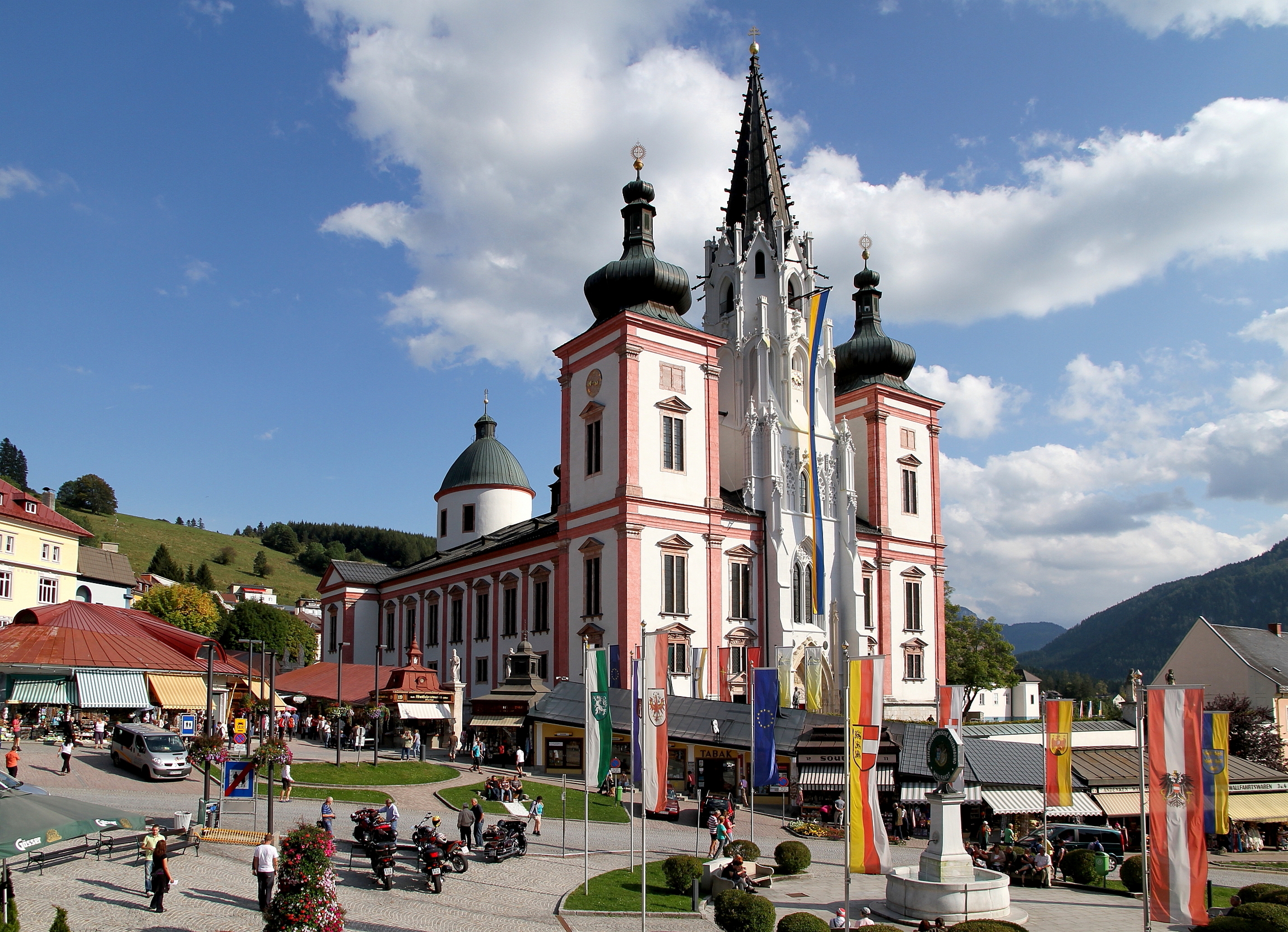
In Lower Austria, all roads don't lead to Rome but to Mariazell. The Via Sacra is Austria’s oldest pilgrimage route, connecting the town of Brunn am Gebirge to Mariazell, Austria’s most important pilgrimage site. In 1975, the Long-distance Hikers’ Organisation of the Alpine Club created the Wiener Wallfarherweg 06 (Vienna Pilgrims' Way 06) as an alternative to this well-known and popular route. The two pilgrimage routes share some stretches and finish in the same place.
Leisurely walking is becoming more and more popular, and for good reason: to escape the stresses of everyday life, to lose sense of time, and to do something good for your body and soul. The Wiener Wallfahrerweg leads you on a 120-kilometre (74 mile) adventure in five stages through untouched forests and meadows to Mariazell. On this long-distance hiking trail, you encounter lots of nature as well as cultural highlights such as monasteries, castles and chapels.
The hike begins from the town of Perchtoldsdorf on the border between Lower Austria and Vienna. On the first day, you hike through the magnificent Föhrenberge Nature Park to the Cistercian monastery of Heiligenkreuz and on to Mayerling village. The second stage takes you to the Arnstein mountain with its magnificent views, to Klein-Mariazell Abbey and finally to the town of Kaumberg.
After a restful night's sleep, you pass the Araburg and climb the Kieneck where you reach alpine heights of more than 1,000 metres (3,280 feet) for the first time. Either spend the night in the Enzianhütte mountain hut or continue hiking to the official destination of the day, Rohr am Gebirge. You can look forward to wonderfully quiet forest passages on the fourth stage, which ends in Sankt Aegyd. The final section of the Way takes you over the Gscheid saddle and past the deep blue Hubertussee lake to the impressive Mariazell Basilica.
The pilgrims' path requires a certain amount of stamina, but alpine experience is not necessary. The paths and trails are all easy to follow and not exposed. If you wish, you can divide the route into more than five stages so that you have more time for breaks and to enjoy the landscape. You spend the nights in guesthouses or holiday accommodation located in smaller stage towns. I recommend booking accommodation in advance.
You can reach the starting point at the market square in Perchtoldsdorf from Vienna with the S-Bahn train or bus. From other parts of Austria, you can travel to Perchtoldsdorf by train and then take the regional bus to the market square. Just outside Mariazell, the destination of the Wiener Wallfahrerweg, there’s a train station. You can return to Vienna via Sankt Pölten, for example.
Carte
Faites-le vous-même
Prêt à vous lancer ? Créez et personnalisez votre propre version de cette aventure en utilisant le Tour complet ci-dessous comme modèle.
Dernière mise à jour : 7 mai 2024
Planifiez votre propre version de cette aventure dans le planificateur multi-jours en vous basant sur les étapes proposées dans cette Collection.
Tours
- 05:3618,8 km3,3 km/h610 m550 mExpertRandonnée - Expert . Excellente condition physique nécessaire. Sentiers facilement accessibles. Tous niveaux.

The Viennese pilgrimage route begins in Perchtoldsdorf on the border between Vienna and Lower Austria. The image of the historic center is shaped by the mighty defense tower, the Sankt Augustin church and the Perchtoldsdorf castle. It pays to allow some time to visit before embarking on your long-distance…
- 07:3225,7 km3,4 km/h770 m590 mExpertRandonnée - Expert . Excellente condition physique nécessaire. Sentiers accessibles pour la plupart. Restez vigilant.
Le deuxième jour du Chemin de pèlerinage de Vienne, près de 26 kilomètres de montées et descentes constantes vous attendent.De Mayerling, il traverse la rivière Schwechat au sud-ouest. Vous marchez au pied du Kritschenkogel en passant par Untermeierhof et jusqu'à Maria Raisenmarkt.
Dans la forêt, vous…
Inscrivez-vous pour découvrir des lieux similaires
Obtenez des recommandations sur les meilleurs itinéraires, pics, et lieux d'exception.
- 08:0925,8 km3,2 km/h1 050 m870 mExpertRandonnée - Expert . Excellente condition physique nécessaire. Sentiers accessibles pour la plupart. Restez vigilant.
La troisième étape est longue de 26 kilomètres et vous attend avec quelques mètres de dénivelé en montée et en descente. Si vous le souhaitez, vous pouvez diviser l'itinéraire et passer une nuit à l'Enzianhütte. Le matin, vous quittez Kaumberg par le village de montagne. La route du pèlerinage viennois…
- 05:5920,5 km3,4 km/h500 m590 mExpertRandonnée - Expert . Excellente condition physique nécessaire. Sentiers accessibles pour la plupart. Restez vigilant.
Après une nuit à Rohr am Gebirge, vous commencez la quatrième étape, caractérisée par beaucoup de nature et d'isolement. Alors s'il vous plaît emballez un peu plus de provisions. De Rohr, vous marchez vers le sud-ouest le long du ruisseau cellulaire. Un peu à l'extérieur du village, vous pouvez escalader…
- 08:1829,0 km3,5 km/h750 m450 mExpertRandonnée - Expert . Excellente condition physique nécessaire. Sentiers accessibles pour la plupart. Restez vigilant.
La cinquième étape est non seulement la finale, mais aussi la plus longue du chemin de pèlerinage viennois et vous attend à nouveau avec de nombreux moments forts. Depuis Sankt Aegyd, il faut d'abord monter le long de l'Unrechttraisen. Vous passerez devant quelques fermes et serez accompagné par l'eau…
Fan de cette Collection ?
Questions et commentaires
Créez un compte komoot gratuit et rejoignez la conversation.
Collection Stats
- Tours5
- Distance120 km
- Durée35:34 h
- Élévation3 670 m3 030 m
Vous aimerez peut-être
Sortie à vélo - Collection par Prisca
Randonnée - Collection par Fred Urrutia
Randonnée - Collection par Éislek
Vélo de route - Collection par Vincent Reboul